File:Time zones of Europe.svg

Original file (SVG file, nominally 512 × 523 pixels, file size: 332 KB)
Captions
Captions
Summary
| DescriptionTime zones of Europe.svg |
Беларуская: Карта гадзінных паясоў Еўропы
Беларуская (тарашкевіца): Мапа гадзінавых пасаў Эўропы
Čeština: Mapa časových pásem v Evropě
Dansk: Kort over Europas tidszoner
Eesti: Euroopa ajavööndite kaart
Ελληνικά: Χάρτης των χρονικών ζωνών της Ευρώπης
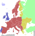
English: Map of the time zones of Europe
Español: Mapa de los husos horarios de Europa
Esperanto: Mapo de Eŭropo-horzonoj
Français : Carte des fuseaux horaires de l'Europe
Italiano: Mappa dei fusi orari dell'Europa
ქართული: ევროპის სასაათო ზონების რუკა
Latina: Tabula Europae tempus zonae
Latviešu: Eiropas kartē laika zonām
Lietuvių: Europos žemėlapis laiko zonų
Magyar: Európa időzónák térképe
Nederlands: Kaart van de tijdzones in Europa
Norsk bokmål: Kart over tidssoner i Europa
Polski: Mapa stref czasowych Europy
Português: Mapa dos fusos horários da Europa
Русский: Карта часовых поясов в Европе
Slovenčina: Mapa časových pásiem Európy
Slovenščina: Zemljevid časovnih pasov Evrope
Suomi: Euroopan kartta aikavyöhykkeiden
Svenska: Karta över Europas tidszoner
Українська: Мапа часових поясів Європи
日本語: ヨーロッパの時間帯の地図
中文(简体):欧洲的时区地图
中文(繁體):歐洲的時區地圖 |
| Date | (UTC) |
| Source | Based on Blank map of Europe.svg, source: Time zones of Europe.png; |
| Author | maix |
| Other versions |
|
| SVG development InfoField |
 | The boundaries on this map show a mix of both de facto and de jure situations. This is just one of several different views on the subject (see COM:NPOV). It may be preferable to represent a consistent approach on this map, unless such a mixing is specifically desired for a particular use case. |
Colours
| Light blue | Western European Time / Greenwich Mean Time (UTC) |
| Blue | Western European Time / Greenwich Mean Time (UTC) Western European Summer Time (UTC+1) |
| Red | Central European Time (UTC+1) Central European Summer Time (UTC+2) |
| Yellow | Eastern European Time / Kaliningrad Time (UTC+2) |
| Golden | Eastern European Time (UTC+2) Eastern European Summer Time (UTC+3) |
| Light green | Further-eastern European Time / Moscow Time / Turkey Time (UTC+3) |
| Light colours indicate where standard time is used all year; dark colours indicate where a summer time (also known as "daylight saving time" or "DST") is used. | |
Licensing
This file is licensed under Creative Commons ShareAlike 1.0 License.
Creative Commons has retired this legal tool and does not recommend that it be applied to works. বাংলা | čeština | Deutsch | English | Esperanto | español | فارسی | suomi | français | magyar | italiano | ქართული | 한국어 | македонски | മലയാളം | português | русский | sicilianu | српски / srpski | svenska | 中文(简体) | 中文(繁體) | +/− | |
| Creative Commons ShareAlike 1.0 GenericCC SA 1.0http://creativecommons.org/licenses/sa/1.0/falsetrue |

|
This work is free software; you can redistribute it and/or modify it under the terms of the GNU General Public License as published by the Free Software Foundation; either version 2 of the License, or any later version. This work is distributed in the hope that it will be useful, but without any warranty; without even the implied warranty of merchantability or fitness for a particular purpose. See version 2 and version 3 of the GNU General Public License for more details.http://www.gnu.org/licenses/gpl.htmlGPLGNU General Public Licensetruetrue |
File history
Click on a date/time to view the file as it appeared at that time.
| Date/Time | Thumbnail | Dimensions | User | Comment | |
|---|---|---|---|---|---|
| current | 13:10, 12 October 2023 |  | 512 × 523 (332 KB) | 3.kor0p (talk | contribs) | Reverted to version as of 23:01, 2 August 2021 (UTC). Crimea is part of Ukraine |
| 01:58, 19 November 2022 |  | 593 × 606 (667 KB) | M.Bitton (talk | contribs) | Reverted to version as of 13:51, 5 April 2022 (UTC): I suggest you read COM:OVERWRITE | |
| 08:48, 17 November 2022 |  | 593 × 606 (666 KB) | Рагин1987 (talk | contribs) | Small correction | |
| 08:44, 17 November 2022 |  | 593 × 606 (666 KB) | Рагин1987 (talk | contribs) | Extended map | |
| 13:51, 5 April 2022 |  | 593 × 606 (667 KB) | Seryo93 (talk | contribs) | Reverted to version as of 06:42, 7 August 2021 (UTC) | |
| 10:22, 27 March 2022 |  | 512 × 523 (332 KB) | Grudzio240 (talk | contribs) | Improvement of time zone in Ukraine according to maps in independent sources e.g. https://maps.lib.utexas.edu/maps/world_maps/time_zones_ref_2015.pdf or https://www.cia.gov/the-world-factbook/static/31913c20666d022fa1315bd444553f8d/world_time.pdf | |
| 06:42, 7 August 2021 |  | 593 × 606 (667 KB) | Seryo93 (talk | contribs) | Reverted to version as of 21:12, 2 August 2021 (UTC) the longstanding consensus is for an actually observed (de facto) time | |
| 23:01, 2 August 2021 |  | 512 × 523 (332 KB) | ThebeOkonma (talk | contribs) | Reverted to version as of 19:48, 2 August 2021 (UTC) - Correcting map error: Crimea is part of Ukraine | |
| 21:12, 2 August 2021 |  | 593 × 606 (667 KB) | Ymblanter (talk | contribs) | Reverted to version as of 20:19, 16 April 2021 (UTC) see talk page, the user has been warned | |
| 19:48, 2 August 2021 |  | 512 × 523 (332 KB) | ThebeOkonma (talk | contribs) | Reverted to version as of 12:52, 16 April 2021 (UTC) - Correcting map error: Crimea is part of Ukraine |
You cannot overwrite this file.
File usage on Commons
The following 35 pages use this file:
- Central European Time
- User:AbdealiJKTravis/logs/newimages/20160726
- User:Chumwa/OgreBot/Potential transport maps/2016 April 21-30
- User:Chumwa/OgreBot/Potential transport maps/2016 July 11-20
- User:Chumwa/OgreBot/Potential transport maps/2016 July 21-31
- User:Chumwa/OgreBot/Potential transport maps/2016 June 1-10
- User:Chumwa/OgreBot/Potential transport maps/2016 June 11-20
- User:Chumwa/OgreBot/Potential transport maps/2016 September 21-30
- User:Chumwa/OgreBot/Potential transport maps/2017 January 11-20
- User:Chumwa/OgreBot/Transport Maps/2015 August 1-10
- User:Chumwa/OgreBot/Transport Maps/2015 August 11-20
- User:Chumwa/OgreBot/Transport Maps/2015 February 10-18
- User:Chumwa/OgreBot/Transport Maps/2015 February 19-28
- User:Chumwa/OgreBot/Transport Maps/2015 October 21-31
- User:Chumwa/OgreBot/Transport Maps/2015 September 21-30
- User:Chumwa/OgreBot/Transport Maps/2016 April 21-30
- User:Chumwa/OgreBot/Transport Maps/2016 July 11-20
- User:Chumwa/OgreBot/Transport Maps/2016 July 21-31
- User:Chumwa/OgreBot/Transport Maps/2016 June 1-10
- User:Chumwa/OgreBot/Transport Maps/2016 June 11-20
- User:Chumwa/OgreBot/Transport Maps/2016 September 21-30
- User:Chumwa/OgreBot/Transport Maps/2017 January 11-20
- User:Chumwa/OgreBot/Travel and communication maps/2016 April 21-30
- User:Chumwa/OgreBot/Travel and communication maps/2016 July 11-20
- User:Chumwa/OgreBot/Travel and communication maps/2016 July 21-31
- User:Chumwa/OgreBot/Travel and communication maps/2016 June 1-10
- User:Chumwa/OgreBot/Travel and communication maps/2016 June 11-20
- User:Chumwa/OgreBot/Travel and communication maps/2016 September 21-30
- User:Chumwa/OgreBot/Travel and communication maps/2017 January 11-20
- User:OgreBot/Watercraft/2016 September 21
- File:Time zones of Europe, incl. Azores and Madeira.svg
- File:Time zones of Europe.png
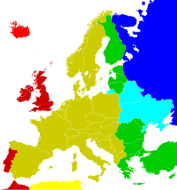
- File:Time zones of Europe (Crimea disputed).svg
- File:Time zones of the Greater Europe.svg
- File:UTC hue4map X region Europe.svg
File usage on other wikis
The following other wikis use this file:
- Usage on af.wikipedia.org
- Usage on ar.wikipedia.org
- Usage on ast.wikipedia.org
- Usage on ba.wikipedia.org
- Usage on be.wikipedia.org
- Usage on bg.wikipedia.org
- Usage on bn.wikipedia.org
- ইউটিসি±০০:০০
- মধ্য ইউরোপীয় সময়
- টেমপ্লেট:ইউরোপের সময় অঞ্চল
- ইউটিসি+০১:০০
- গ্রিনিচ মান সময়
- ইউটিসি+০২:০০
- ইউটিসি+০৩:০০
- পূর্ব ইউরোপীয় সময়
- পশ্চিম ইউরোপীয় সময়
- মধ্য ইউরোপীয় গ্রীষ্মকালীন সময়
- কালিনিনগ্রাদ সময়
- মস্কো সময়
- ব্রিটিশ গ্রীষ্মকালীন সময়
- পূর্ব ইউরোপীয় গ্রীষ্মকালীন সময়
- তুরস্ক সময়
- পশ্চিম ইউরোপীয় গ্রীষ্মকালীন সময়
- Usage on bs.wikipedia.org
- Usage on ca.wikipedia.org
View more global usage of this file.
Metadata
This file contains additional information such as Exif metadata which may have been added by the digital camera, scanner, or software program used to create or digitize it. If the file has been modified from its original state, some details such as the timestamp may not fully reflect those of the original file. The timestamp is only as accurate as the clock in the camera, and it may be completely wrong.
| Short title | Countries of Europe |
|---|---|
| Image title | A blank Map of Europe. Every country has an id which is its ISO-3166-1-ALPHA2 code in lower case.
Members of the EU have a class="eu", countries in europe (which I found turkey to be but russia not) have a class="europe".
Certain countries are further subdivided the United Kingdom has gb-gbn for Great Britain and gb-nir for Northern Ireland. Russia is divided into ru-kgd for the Kaliningrad Oblast and ru-main for the Main body of Russia. There is the additional grouping #xb for the "British Islands" (the UK with its Crown Dependencies - Jersey, Guernsey and the Isle of Man) and the Kingdom of Denmark (Denmark, Faroe Islands, Greenland)

Contributors.
Original Image: (http://commons.wikimedia.org/wiki/Image:Europe_countries.svg) Júlio Reis (http://commons.wikimedia.org/wiki/User:Tintazul).
Recolouring and tagging with country codes: Marian "maix" Sigler (http://commons.wikimedia.org/wiki/User:Maix)
Improved geographical features: http://commons.wikimedia.org/wiki/User:W!B:
Updated to reflect dissolution of Serbia & Montenegro: http://commons.wikimedia.org/wiki/User:Zirland
Updated to include British Crown Dependencies as seperate entities and regroup them as "British Islands", with some simplifications to the XML and CSS: James Hardy (http://commons.wikimedia.org/wiki/User:MrWeeble)
Validated (http://commons.wikimedia.org/wiki/User:CarolSpears)
Changed the country code of Serbia to RS per http://en.wikipedia.org/wiki/Serbian_country_codes and the file http://www.iso.org/iso/iso3166_en_code_lists.txt (http://commons.wikimedia.org/wiki/User:TimothyBourke)
Uploaded on behalf of User:Checkit, direct complaints to him plox: 'Moved countries out of the "outlines" group, removed "outlines" style class, remove separate style information for Russia' (http://commons.wikimedia.org/wiki/User:Collard)
Updated various coastlines and boarders and added various islands not previously shown (details follow). Added Kosovo, Northern Cyprus, Crimea, Abkhazia, South Ossetia, Transnistria and Nagorno-Karabakh as disputed territories. Moved major lakes to their own object and added more. List of updated boarders/coastlines: British Isles (+ added Isle of Wight, Skye, various smaller islands), the Netherlands, Germany, Austria, Hungary, Czech Republic, Denmark, Sweden, Finland, Poland, Kaliningrad Oblast of the Russian Federation (and minor tweaks to Lithuania), Estonia, Ukraine, Moldova (minor), Romania, Bulgaria, Turkey, Greece, F.Y.R. Macedonia, Serbia, Bosnia and Herzegovina, Montenegro, Albania, Croatia, Italy (mainland and Sicily), Malta (http://commons.wikimedia.org/wiki/User:Alphathon).
Added Bornholm (http://commons.wikimedia.org/wiki/User:Heb)
Released under CreativeCommons Attribution ShareAlike (http://creativecommons.org/licenses/by-sa/2.5/). |
| Width | 100% |
| Height | 100% |


.svg/264px-Time_zones_of_Europe_(Crimea_disputed).svg.png)
